Ba'jaBa‘ja 2007: Crawl Spaces, Rich Room Dumps, and High Energy Events.
Hans Georg K. Gebel, Free University of Berlin |
Ba‘ja 2007: Crawl Spaces, Rich Room Dumps, and High Energy Events. Results of the 7th Season of Excavations
|
|||||||||||||||||||||||||||
Huge Rubble and Fine Gravel Flows, Wall Rubble and Air PocketsArea B-South, B72 and B73 (Fig. 7)The northern halves of both squares located close to the flat central part of Area B were opened in order to trace evidence of the supposed open space in central Area B. After the fine-grained layers (FGM) characteristic for the site‘s sub-topsoil stratigraphy were removed, excavation was suspended on top of greyish cultural debris layers containing redeposited smaller stones, disintegrated charcoal, and artefacts (at ca. 50 cm below the surface). Only in the north half of B73 was excavation continued for about 40 cm deeper into these cultural debris layers. The relationship between the thick fluvial flow of fist-sized stone rubble containing fine gravel lenses (RF/FGL) of B64 and B74 and the greyish cultural debris layers in B73 could not be clarified. It was astonishing to recognize here different layers at similar heights and in close vicinity (Baulk B73/74), which probably do not have the same origins, interact with each other.
|
||||||||||||||||||||||||||||
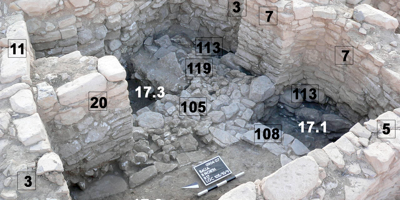
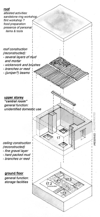
Area B-South, Lower B64 (Figs. 7-8)Excavation continued in the southern half of B64 to gain more insights into the huge intrasite rubble and gravel flows (RF/FGL) resting against high walls and on the large wall rubble accumulations, features that presumably result from high energy events like flash floods and earthquakes. The same features are reported from Area C (see below) at a distance of some 20-30 m. Observations and more evidence from this season allow us now to raise the topic of catastrophic impacts on settled life in Ba‘ja.
The oldest wall remains exposed so far in southern B64 run roughly E-W (Loc. 26 in the east, Loc. 29 in the west under Wall 13). To the south of these walls extends a huge accumulation of wall rubble and loose sediment with air pockets (Loc. 24) that evince an episode of rapid destruction and/or deconstruction, at any rate representing high energy events or its consequences. It could be the result of a major earthquake followed by the intentional burial of material from deconstructed walls. Above Locus 24, Locus 21 was found to be of similar origin but with quite a number of air pockets between the stones, mixed also with a higher amount of loose, redeposited material including mortar/ plaster/ ceiling debris containing charcoal. Locus 21 reaches heights of the basal parts of Wall 13; Locus 21 especially looks like freshly deposited debris of a disastrous event. Above Locus 21 rests Locus 16, again with much wall rubble and air spaces, reaching heights of the central preserved part of Locus 13 wall. Wall Locus 13 runs into the lower cobble-faced phase of Wall 4 that rests on a layer of pure and densely packed ceiling/ mortar/plaster material (Loc. 23). The stratigraphic relation of Layer 23 to Wall 29 is that it is a later fill than Wall 29. Layer 23 must have been deposited while the wall rubble Layers 24, 21, and 16 were accumulated. Only after this rapid deposition of wall rubble Wall 13 was built. It used Wall 29 as a foundation, which still bore patches of red plaster (e.g. Loc. 19 in 2007). Wall 13 seems to have been reduced in height, probably during the erection of the upper phase of Wall 4 (= coarse-faced upper part of Wall 4). On top of Wall 13 rests the moraine-type flow of fist-sized rubble/ gravel with embedded fine gravel lenses (RF/FGL) that is also attested in the east sections of B64 and B74. In an interpretation of the events in Area B-South we may identify three major high-energy impacts. The first is related to the wall rubble accumulation with air spaces that has a minimum thickness of 1.5 m (not fully excavated yet) in lowermost B64, which seems to be the result of an earthquake destruction of the lowermost architecture in the area and of subsequent intramural space filling. The second relates to the huge fluvial rubble/gravel flow (RF/FGL) resting against the walls of the next building phase (cf. also the fine gravel deposits inside the “gate” in B74), which must have filled also empty spaces in central Area B. The thickness of the flow reaches 1.5 m in spots, and it might represent more than a single event (e.g. embedded fire places). The third is represented by the twisted walls in upper B83 and B84 (Fig. 7): The energy made walls lean in all directions and did not follow a specific vector or pattern, which also leads us to conclude that this resulted from an earthquake. |
|
|||||||||||||||||||||||||||
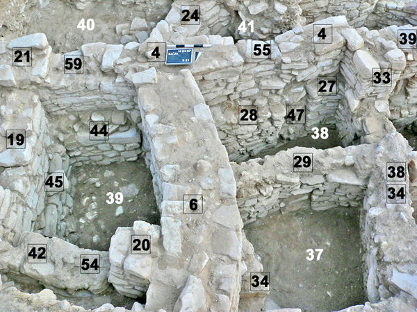
Area C, Square C-10, Baulks C-20/20 and C-10/10 (Fig. 9)The operation in C-10 and the baulk removals in C-20/20 and C-10/10 were aimed to clear a stairwell location in C-20/20 that connected two occupational levels in C-10/10/-20/20/21 in order to understand a later building phase resting on the fist-sized rubble/ gravel flow with embedded fine gravel lenses (RF/FGL), as well as to link the C-10 architecture with that of C10 and C20. Like B64 and B74, western Area C reflects two major impact events: an extensive earlier wall rubble pile with air pockets in C20 (incompletely excavated) in a rather large open space, a huge rubble and gravel flow resting against high standing walls, e.g. Walls 10/11 of C-20/20, before the reorganization of space and architecture of the upper architectural phase took place. After six seasons in Ba‘ja, we could distinct a separate and later architectural phase, which is not part of the overall architectural and morphodynamic complexity of succeeding modifications that prevent the identification of clear and general sub-phases. The operations in western Area C allowed us to connect the building stratigraphy around the open space in C20 with the remains in C-10. After the removal of the baulks it became clear that Wall 5 of C-10 continues in C10; together with Buttress 114 of C10 and Wall 6 of C-10, this E-W running wall represents the latest architectural phase in the area. It runs against the big and reinforced buttressed terrace Wall in C1 and C10-11 (Bienert and Gebel 2004: 125). It is erected on the RF/FGL flow with layers of small fluvially sorted and laid gravel (8-15 mm), and this is also the case for Buttress 114, Wall 6, and Buttress 26 in C-10. These water-laid fine gravels are also found in the north section of C20, where they accumulated against the eastern face of Wall 10 (former Baulk C-20/20). Here these fine gravels appear as lenses and layers inside the upper parts of a rubble/ gravel flow, consisting of fist-sized stones, that forms the upper fill of the rooms in C-10 and Baulk C-20/C20. In the corner east of Walls 6 and 5 a dense and hard greyish layer (Loc. 25) of mainly fist-sized stones was found in which a stone-lined box (Loc. 19) was inserted. All the aforementioned wall remains were covered by the light brownish fine-grained material (FGM) forming the sub-topsoil layer in all Areas A and C; its thickness reaches 60 cm. The RF/FGL rubble/gravel seems to have terminated the earlier architectural occupation in western Area C, causing the reorganization of its space. This earlier occupation is represented in C20 by Walls 120 (with two blocked window-like wall openings = Loc. 127, earlier plastered in red inside), 128 (in the north baulk), 133 (with Wall Opening 134), Staircase 129, and Walls 10 and 11, 7 and 8 in Baulk C-20/20. The destruction of this phase seems to be evidenced by the deposition of the huge wall rubble in the open space of C20 and in the space between the Walls 120 in C20 and 5, 26 and 8 in C-10 (where also many lintel stones were found). The orientations of this wall rubble are mixed; the deposits have a lot of air pockets, revealing a rapid and probably intentional filling of the space. It is assumed that this action relates to the deconstruction of walls that followed a high-energy event like an earthquake. This must also have twisted the complete Stairwell 129, simultaneously leaning it down by the height of one step. This high-energy event may not be related to the destructive event represented by the rubble and gravel flows described above. It is rather clear that the destruction of architecture (“earthquake”) and subsequent intramural filling with its wall rubble preceded the rubble/ small gravel flows entering, for example, the second room to the north of the stairwell. Water appears to be the agent of transport and movement in this destruction phase before the latest walls in western Area C were erected. This combined evidence of earthquake or earthquake-like destruction3 and rubble/ fine gravel flow is also attested in B-South, especially B64, where similar fine gravel layers inside a major sequence of rubble/gravel flows (ca. 1.5 m) rest against Wall 4, also entering inside the “gate” in that wall in B74. |
|
|||||||||||||||||||||||||||
Ba'ja Projekt |
Eastern Jafr Project |
Bookshop & Publications Free Downloads |
About us |
Associated Projects, Cooperations PPND (Neolithic Radiocarbon Dates) Neolithic Heritage Trail (u.c.) |
Donations |
News & Activities |
|